-40%
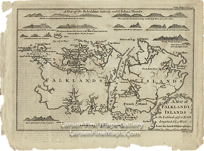
1770 Antique Map of Falklands Islands from Latest Observations
$ 16.36
- Description
- Size Guide
Description
1770 Antique Map of Falklands Islands from Latest ObservationsChart of the Falkland Islands five to six years after its first settlement by a French Colony. It was during the time of the short conflict between Spain and Britain over control of the island group. Coastal elevation views show the various approaches to the islands. Carlisle Sound, Byron's Sound, Berkley Sound, Port Stephens, Brett's Harbor, Egmont Port, and many other locations are called out on the chart. Published in Gentleman's Magazine October 1770.
1770 Antique Map of Falklands Islands from Latest Observations
YEAR PUBLISHED:
1770
CARTOGRAPHER/MAPMAKER:
J. Lodge sculp.
PUBLICATION:
Gentleman's Magazine, London
PUBLISHER:
Gentleman's Magazine, London
FULL TITLE:
A Map of Falklands Islands in the Latitude of 51°,22' South, Longitude 64°,30' West: From the latest Observations.
CONDITION:
G, small uncolored, tears and missing parts outside of neatline.
DIMENSIONS:
9.5 X 6.5
DESCRIPTION:
Chart of the Falkland Islands five to six years after its first settlement by a French Colony. It was during the time of the short conflict between Spain and Britain over control of the island group. Coastal elevation views show the various approaches to the islands. Carlisle Sound, Byron's Sound, Berkley Sound, Port Stephens, Brett's Harbor, Egmont Port, and many other locations are called out on the chart.
Published in Gentleman's Magazine October 1770.
×
Buy now and save!
Tell a friend
Visit store
Watch now
Postage info
Click the Postage tab above the listing description for more info
FREE Postage
Click the Postage tab above the listing description for more info!
Additional delivery notes
PICK UP OPTION
Sorry, our items are NOT available for pick-up.
PAYING VIA PAYPAL
We accept PayPal on our all our items so you can shop with confidence.
Simple choose the PayPal option when proceeding through the checkout.
Additional Information
No additional information at this time
Ask seller a question
You might also like
1951 Vintage Map of Greenfield Village, Thomas A. Edison, Henry Ford
1829 Antique Map of The County of Surrey
1829 Antique Map of The County of Sussex
1880 Antique USGS Progress Map, George Wheeler
Contact
To contact our Customer Service Team, simply click the button here and our Customer Service team will be happy to assist.
Ask seller a question
© Larsen Fine Maps Gallery
Postage
Shipping is FREE for this item
Payment
Accepted Payment Methods
PayPal
Returns
Returns are
not
accepted
Buyer will pay for return shipping.
eBay integration
by


